Location
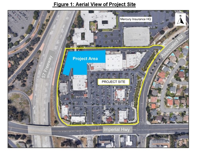
The Project site, commonly known as the Brea Plaza, is approximately 15.5-acres and is bounded to the east by Associated Road, Imperial Highway to the south, and California State Highway 57 (Orange Freeway) to the west. The Project area is approximately 2.2-acres and is located in the northwestern portion of the site. Figure 1 below shows the Project site outlined in yellow, with Project area highlighted in blue.
General Plan / Zoning
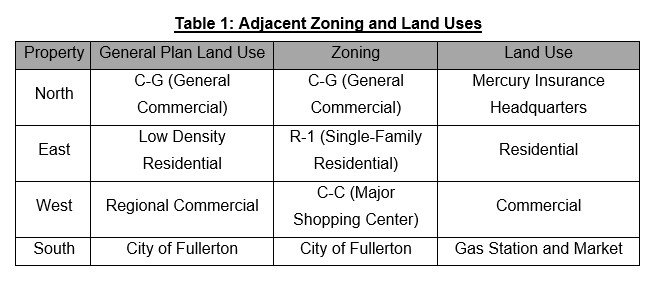
The Project site currently has a General Plan Land Use designation and zoning of C-G. Table 1 and Figure 2 below provide the General Plan Land Use designation and zoning of the site and adjacent properties.
Existing Conditions
The Project site is currently developed with approximately 165,329 square-feet of commercial uses comprised of retail stores, restaurants, and a five-screen movie theater (that has remained closed since the start of the COVD-19 pandemic). The site maintains a 739-space surface parking, landscaping, lighting, and monument and way-finding signs. Vehicular access to the site is provided from Associated Road and from Imperial Highway.
The Project site currently utilizes a reciprocal access agreement with the Mercury Insurance property to the north. This agreement grants vehicular access and circulation between both properties, and provides the Project site access to the Mercury Insurance parking lot for an additional 180 parking spaces during business hours, and all surface spaces (approximately 500 spaces) after 5:00 P.M. on weekdays and all day on weekends. The reciprocal access agreement is provided through a memorandum of understanding (Attachment H), which is in effect until April 2026 unless an extension is agreed upon by the Applicant and Mercury Insurance.
Entitlement History
On November 25, 1975, the Planning Commission adopted Resolution No. PC 305-75 (Attachment I), approving Precise Development No. 19-75 to allow the construction of Brea Plaza. Resolution No. PC 305-75 also certified an associated Environmental Impact Report (EIR) pursuant to CEQA.
On December 28, 1976, the Planning Commission adopted Resolution No. PC 405-76 (Attachment J), approving Precise Development No. 20-76 to allow four commercial buildings within the Brea Plaza Shopping Center. Two of these buildings are presently occupied by Buca Di Beppo and Lucille’s BBQ, while the other two buildings have been demolished.
On April 27, 1982, the Planning Commission adopted Resolution No. PC 27-82 (Attachment K), approving Conditional Use Permit (CUP) No. 20-81 to establish an amusement center.
On February 12, 1991, the Planning Commission adopted Resolution No. PC 91-8 (Attachment L), approving CUP No. 90-30 to establish a sign program for Brea Plaza.
On May 11, 1993, the Planning Commission adopted Resolution No. PC 93-26 (Attachment M), approving Precise Development No. 93-1, CUP No. 93-8, and adopting Negative Declaration No. 93-6 to allow the renovation of the Brea Plaza Shopping Center, including the addition of tenant space, demolition of buildings, landscaping and lighting improvements, and redesign of the parking lot for an increase of 117 parking spaces, with 23 percent compact spaces. Approval included a new comprehensive sign program for the site.
On October 11, 1994, the Planning Commission adopted Resolution No. PC 94-47 (Attachment N), approving amendments to Precise Development No. 93-1, CUP No. 93-8, and Negative Declaration No. 93-6. Amendments consisted of the addition of a fifth screen at the movie theater, a reduction to building floor area to expand the parking lot and add 14 parking spaces, and modification to the Brea Plaza sign program.
On June 10, 2008, the Planning Commission adopted Resolution No. PC 08-12 (Attachment O), approving Precise Development No. 08-01, CUP No. 08-03, and adopting Mitigated Negative Declaration No. 08-01 to expand the Brea Plaza Shopping Center with two new buildings, including a drive-through food use (Chick-fil-A Restaurant), the demolition of three structures, and allow an improved parking lot over the Loftus Channel.
On December 8, 2009, the Planning Commission adopted Resolution No. PC 09-29 (Attachment P), approving Precise Development No. 09-01, CUP No. 09-14, and an addendum to Mitigated Negative Declaration No. 08-01 to allow the reconfiguration and partial demolition of two buildings, three new buildings including two drive-thru restaurants, and a new sign program for the site. The three new buildings allowed under this approval were: 1) the Chick-fil-A building with drive-through (carry-over from 2008 approval), 2) multi-tenant building with Panera Bread with drive-through, and 3) multi-tenant building with FedEx Office.
On April 30, 2019, the Applicant filed a request to demolish the Brea Plaza 5 Cinema and the Buca di Beppo restaurant building, to allow an approximately 226,855 square foot, seven-story (two stories of parking and five stories of residential and office), 84-foot tall, mixed-use building with a parking garage containing 347 parking spaces, 194 dwelling units, 17,863 square feet of office space, 5,019 square feet of restaurant, and a 92,538 square foot, six-story 150-room hotel. Since the initial submittal, the Project has been scaled down and revised.
PROJECT DESCRIPTION
The Project proposes the demolition of an existing 1,100-seat five-screen movie theater and 139 surface parking spaces, to facilitate the construction of an approximately 243,112 square-foot mixed-use building with five stories containing 189-residential dwelling units, 21,355 square-feet of office space, above a three-story parking garage with 397 parking spaces.
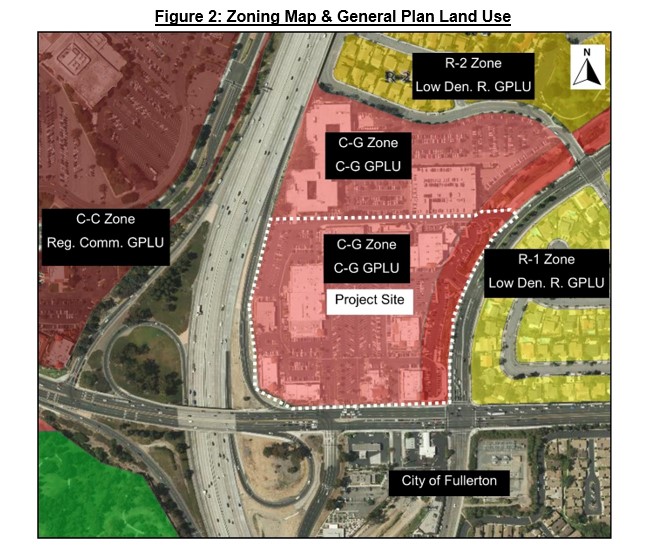
Parking
The Project proposes a three-story, 33-foot tall, podium parking garage containing 397 parking spaces. Vehicular access to the proposed parking garage would be provided through three 26-foot wide driveways. Two of these driveways are located at the southern elevations of the garage structure and one is located at the northern elevation. All-access driveways into the parking garage include dedicated directional lanes providing ingress and egress. The ground floor of the proposed parking garage would include a lounge for rideshare drivers, an office lobby, and 130 bicycle parking spaces. The Project would also provide 60 charging stations for electric vehicles distributed throughout the parking garage.
Figure 3 below provides an exhibit of the proposed parking garage and location of the vehicular access points.
Residential
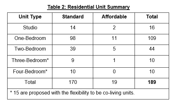
The residential component of the project proposes a five-story building atop the previously described three-story parking structure. Table 2 provides a breakdown of the proposed 189 residential units range in size from studio to 4-bedroom apartment units. Of the 189 residential units, 15 units are set aside with the flexibility to be co-living apartments that provide communal living in which residents would have a private bedroom with shared common areas. Alternatively, these co-living units could be rented as 3 and 4 bedroom units. The Project would set aside 19 low-income units consistent with the City’s Affordable Housing Ordinance.
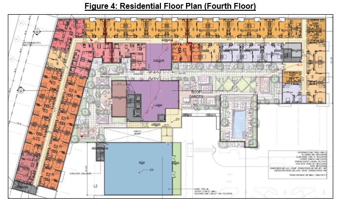
The proposed 222,757 square foot residential building would include a fourth floor amenity terrace deck with a garden, open space, and a pool. Figure 4 shows the proposed fourth story floor plan containing residential dwelling units and the amenity terrace deck providing common open space as required by Section 20.258.020 of the Brea City Code (BCC).
Office
The Project proposes 21,355 square feet of office space including a 500 square foot ground floor lobby, a 3,628 square foot office on the third story, and a two-story 14,516 square foot office on the fourth and fifth stories of the proposed mixed-use building. The offices would have open floor plans that could be build to suit with varying sizes. The office areas of the mixed-use building would be accessed through dedicated elevators and walkways. The office uses would have general operating hours from 8:00 AM to 5:00 PM during the week, and closed on weekends.
ANALYSIS
General Plan Amendment
Land Use Designation
The Project proposes to change the General Plan Land Use designation of the site from C-G to MU-I. The mixed-use designation encourages development that combines commercial uses and residential dwelling units in order to reduce vehicle trips and vehicle miles traveled by locating residents, jobs, and services near each other; to improve air quality through a reduction of vehicle trips and vehicle miles traveled; to provide for a variety of housing opportunities, including senior housing; to improve the efficiency of public services, systems, and utilities; and to promote design quality and flexibility.
The MU-I designation allows for intense, mixed-use urban environments that offer opportunities for people to live, work, shop, and recreate without having to use their cars. This designation encourages vertical integration of compatible residential and commercial uses, whereby such uses share the same building or lot. The Mixed-Use I designation applies to Downtown Brea, and the Birch Street Corridor, as well as other infill sites located throughout the community with ready access to major roadways and public transit.” The approximately 15.5-acre Brea Plaza Shopping Center offers shopping opportunities through various types of retail, office, and restaurant uses, that create and support an employment base. The Project site has access to major roadways via Imperial Highway, and it is adjacent to the 57-freeway. The Project would further enhance the intent of the MU-I Land Use designation at the site by introducing 189 residential dwelling units and 21,355 square feet of office space. Therefore, the Project site is suited for the MU-I Land Use designation.
The Project would allow people the opportunity to live, work, and shop on-site, where the use of a vehicle would be limited or sometimes not required. The Project would introduce vertical integration of residential and office uses contained within a single building, on an infill site with existing access to major roadways and public transit routes along Imperial Highway and Associated Road. Therefore, the Project would consistent with the intent of the MU-I Land Use designation.
General Plan Goals and Policies
To plan for the present and future needs of the City, the General Plan provides goals and policies to guide development. The Project would adhere to the following goals and policies found in the General Plan.
Goal CD-1 Provide a balance of land uses to meet the present and future needs of all residents.
The Project would adhere to Goal CD-1 by providing residential dwelling units and office facilities that would serve the City’s existing residents and workforce, and those seeking to relocate to Brea. The Project would create a variety of housing opportunities by providing studio to four-bedroom dwelling units, including 19 allocated for low income.
Policy CD-1.9 Encourage new development that is organized around compact, walkable, mixed-use neighborhoods and districts to conserve open space resources, minimize infrastructure costs, and reduce reliance on the automobile.
The Project would adhere to Policy CD-1.9 by creating a mixed-use in-fill development, without affecting open space throughout the City. The Brea Plaza Shopping Center is characterized by a horizontal mix of restaurant, retail, and office uses, and the Project would add residential opportunities that presently don’t exist in the vicinity. The Project would provide residents living at the site the convenience of walking to shops, restaurants, grocery stores, and to work, thereby reducing vehicle reliance.
Policy CD-23.2 Provide opportunities for mixed-use, office, manufacturing, and retail development that respond to market and community needs in terms of size, location, and cost.
The Project would adhere to Policy CD-23.2 by providing mixed-use development that would serve a new population of residents that would desire to live onsite where commercial and retail amenities are within walking distance. Of the 189 residential units, 19 would be set aside for low-income households, thereby contributing to the City’s requirement to provide low-cost housing mandated by the State Department of Housing and Community Development (HCD) through the regional housing needs assessment (discussed further in this report).
Policy CD-26.3 Explore opportunities for mixed-use development projects on sites historically supporting commercial centers.
The Project would adhere to Policy CD-26.3 by allowing a mixed-use development on a site that has been developed and maintained as a commercial shopping center since 1976.
Housing Element
The City’s 6th Cycle Housing Element (2021-2029) sets forth a housing vision that includes programs and related objectives to plan for adequate affordable housing, suitable housing sites, removal of governmental constraints, and promotion of equal housing opportunities. The Housing Element sets forth a plan to address the identified housing needs of the City, and includes the following goals, policies, and programs that are related to this Project.
Policy 1.4 Encourage residential and mixed-use developments that focus on building community, incorporating outdoor features as living space, as well as providing a mix of amenities that benefit the surrounding neighborhood.
The Project would adhere to Policy 1.4 by allowing a mixed-use development with 189 residential dwelling units and communal areas including a terrace deck on the fourth story with garden, open gathering space, and a pool. The Project would provide residential units that could be occupied by employees of neighboring commercial uses, such as Mercury Insurance to the north, and office space that could be occupied by neighboring residents. Therefore, through its desgin, the Project would focus on building community with outdoor features.
Policy 2.2 Utilize the City’s Inclusionary Housing Ordinance as a tool to integrate affordable units within market rate developments, or pay an in-lieu fee to support the provision of affordable housing.
The Project would adhere to Policy 2.2 by setting aside 19 residential units for low income, thereby providing low-cost housing within a market rate development.
Goal 3.0 Provide adequate housing sites through appropriate land use, zoning, and specific plan designations to accommodate Brea’s share of regional housing growth needs
The Project would adhere to Goal 3.0 by by providing new residential dwelling units that would count towards the City’s RHNA of 2,365 dwelling units. The Project would contribute 189 residential units towards the City’s unit production, including 19 affordable units.
Policy 3.2 Provide opportunities for mixed use and infill housing development opportunities in the Brea Core as part of the City’s ongoing revitalization strategy for the area.
The Project would adhere to Policy 3.2 by allowing a mixed-use infill housing development within the Brea Core, aligned with the City’s objective to integrate high-density development projects within the Brea Core area. The Brea Core is further described in this report.
Policy 3.3 Promote the efficient use of land by encouraging commercial and residential uses on the same property in both horizontal and vertical mixed-use configurations.
The Project would adhere to Policy 3.3 by allowing the introduction of a mixed-use building with residential and office uses, over a 2.2-acre area within the 15.5-acre Brea Plaza Shopping Center. The proposed mixed-use building is designed with horizontal and vertical features that include building modulation, building step-backs, and exterior finishes that would be integrated with, and complementary to, the existing commercial development on the site.
Policy 6.6 Encourage a closer link between housing and jobs in the community, including housing opportunities affordable to Brea’s modest income workforce.
The Project would adhere to Policy 6.6 by providing housing adjacent to employment opportunities found within the existing Brea Plaza Shopping Center and employees of neighboring commercial uses, such as Mercury Insurance to the north. The proposed co-working office areas could be used by residents in the mixed-use building and by residents in the vicinity. The Project would allocate 19 residential units for low income, that could support modest-income workforce.
Brea Envisions & Brea Core Plan
In 2016, the City initiated Brea Envisions as an outreach and engagement effort to provide residents opportunities to express their hopes and desires for their neighborhoods and the City. Through an interactive process that included; the “Be Committee”, informational campaigns, Brea Ambassadors, online questionnaire, and a community open house; community members provided feedback on their vision for the future of Brea. Outreach results showed a desire for expanding the City’s retail and service base, while creating jobs and housing.
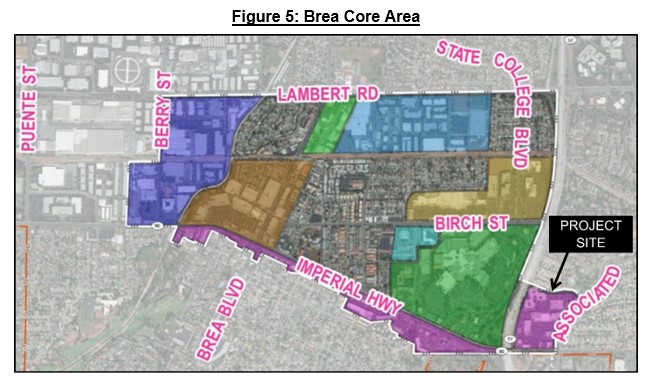
Subsequently, the Brea Core Plan was initiated to implement Brea Envisions community feedback. The Brea Core Plan explores opportunities to strengthen the retail, services, and jobs sectors, while determining how best to satisfy the City’s affordable housing obligation. In addition, the City’s 6th Cycle Housing Element (years 2021-2019) calls for the creation of a Specific Plan for the Brea Core, intended to provide standards and guidelines for new development focused on higher densities. Under the 6th Cycle Housing Element Implementation Program No. 9, the Specific Plan would re-designate most commercially zoned properties in the Brea Core to allow for mixed-use. The area of the Brea Core covers the central region of the City, and includes the Project site. Figure 5 below shows the Brea Core Plan area, with the Project site identified at the southeastern boundary.
The Brea Core Plan identifies the Project site as a mixed-use corridor and transition area, where it is recommended that residential development near jobs and shopping be allowed. Further, the Brea Core Plan recommends providing for mixed-use strategies to allow additional housing development that is well connected to shopping activity areas. The Project would satisfy the findings and objectives of the Brea Core Plan by allowing mixed-use development, with affordable housing, adjacent to commercial and retail uses.
Vehicle Circulation
The Project site would continue to be served by the existing Brea Plaza driveways, including the signalized intersection of Imperial Highway at SR-57 NB Ramps/Brea Plaza; a right-turn-only driveway on Associated Road; a full access unsignalized driveway on Associated Road; and a right-turn-only driveway on Imperial Highway. City staff, in consultation with Linscott, Law and Greenspan (LLG) Engineers, evaluated on-site circulation in terms of vehicle-pedestrian conflicts. The Project’s overall layout would not create any unsafe vehicle-pedestrian conflict points, and the driveway approaches would remain sufficient to prevent internal vehicle queuing/stacking from affecting access to parking spaces. The circulation around the buildings would provide sufficient sight distance along the drive aisles. Therefore, as proposed, the Project would not result in impacts related to on-site vehicle circulation.
Circulation Element
The Circulation Element of the General Plan provides goals and policies for efficient regional transportation facilities, the local circulation system, the public transportation system, and pedestrian and bicycle facilities throughout the City. The City’s transportation network includes roadways and pedestrian, bicycle, and public transit facilities to allow for the movement of persons and goods in the City. The Circulation Element evaluates the ability of the City’s transportation network to serve residents and businesses by establishing performance criteria expressed in terms of Level of Service (LOS). LOS has a range from “A” to “F”, with LOS A representing free-flow traffic and LOS F representing extreme congestion.
While LOS is no longer a factor pursuant to CEQA, for General Plan conformance, a Traffic Circulation Assessment (TCA) was prepared by LLG to assess the Project’s effect on the City’s transportation network. This assessment was reviewed by City staff, in concurrence with the City’s Traffic Engineer, and is included as Appendix J2 of the Project Draft EIR, provided as Attachment Q. The TCA studied nine intersections that provide regional and local access to the Project site, and evaluated peak hour intersection queuing and existing and proposed vehicle trip generation to the site. The studied intersections are listed below:
1. State Route 57 (SR-57) SB Ramps at Imperial Highway
2. SR-57 NB Ramps/Brea Plaza Driveway 1 at Imperial Highway
3. South Associated Road at Birch Street
4. South Associated Road at Greenbriar Lane
5. South Associated Road at Imperial Highway
6. Castlegate Lane/Placentia Avenue at Imperial Highway
7. South Associated Road at Brea Plaza Driveway 2
8. South Associated Road at Brea Plaza Driveway 3
9. Brea Plaza Driveway 4 at Imperial Highway
LLG’s queuing and LOS evaluation was conducted for future near-term (Year 2024) cumulative traffic conditions with Project conditions, and long-term (Year 2045) General Plan buildout traffic with Project conditions. The study found that, with the addition of the Project, these intersections would continue to operate at the existing LOS grade (level D) or better during the weekday AM and PM peak hours, and therefore, no LOS impacts are anticipated. The queuing evaluation was based on average queue methodology, which calculates the average queue value in terms of number of vehicles per lane. Furthermore, a review of SR-57 NB Ramps/Brea Plaza Driveway 1/Imperial Highway (Intersection #2) indicated that the proposed Project would not adversely affect the queues at the intersection or adversely contribute to the potential weaving along Imperial Highway between the SR-57 northbound on-ramp and Brea Plaza Driveway 1. Therefore, the Project would not produce traffic related impacts associated with vehicle queuing for near- and long-term conditions.
LLG’s assessed existing and proposed vehicle trip generation to the Project site, that considered the proposed demolition of the movie theater. LLG’s assessment found that, the Project would result in 1,680 fewer weekday daily trips, 100 more weekday AM peak hour trips, and 60 fewer weekday PM peak hour trips, as well as 2,282 fewer Saturday daily trips, and 489 fewer Saturday midday trips. As a result, a Saturday analysis is not recommended. Further, none of the nine studied intersections are forecast to exceed the City’s Level of Service (LOS) criteria thresholds. Therefore, the Project would not produce traffic related impacts associated with vehicle trips.
LLG also collected collision data (Appendix J2 of the Project Draft EIR provided as Attachment Q) from the Statewide Integrated Traffic Records System (SWITRS) for the timeframe of May 2016 through May 2021 for the following six key signalized intersections in the Project vicinity (three of the intersections listed above were omitted since they do not contain a signal):
1. State Route 57 (SR-57) SB Ramps at Imperial Highway
2. SR-57 NB Ramps/Brea Plaza Driveway 1 at Imperial Highway
3. South Associated Road at Birch Street
4. South Associated Road at Greenbriar Lane
5. South Associated Road at Imperial Highway
6. Castlegate Lane/Placentia Avenue at Imperial Highway
Data shows that accidents at these intersections have generally declined within the last five years, with no reported accidents at the Brea Plaza driveways. Decrease in collisions is attributed to Caltrans improvements that have enhanced safety along Imperial Highway, including traffic signal and American Disabilities Act (ADA) improvements.
MU-I Zone Development Standards
The Project proposes to change the zoning of the site from C-G to MU-I, which is intended for areas for intense, mixed-use urban environments that offer opportunities for people to live, work, shop, and recreate without having to use their vehicles. This designation encourages vertical and horizontal integration of compatible residential and nonresidential uses, whereby the uses share the same structure or parcel. The Mixed-Use I designation applies to Downtown Brea, including the Birch Street Corridor, as well as other sites located throughout the community with ready access to major roadways and public transit.
The Project would create a mixed-use development by allowing 189 residential units and 21,355 square-feet of office space. This would provide people the opportunity to live, work, and shop onsite, where use of a vehicle would be limited or sometimes not required. The Project would introduce vertical integration of residential and office uses contained within a single building, on an infill site with existing access to major roadways and public transit routes along Imperial Highway and Associated Road. Therefore, the Project would adhere to the intent of the MU-I zone.
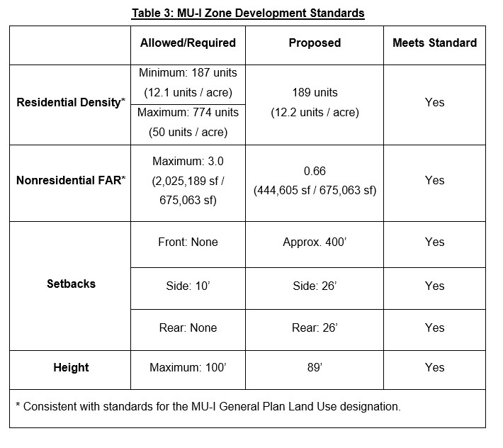
Development in the MU-I zone is regulated by Section 20.258.020 of the BCC. As shown in Table 3 below, the Project complies with the MU-I zone development standards for residential density, nonresidential floor area ratio (FAR), setbacks, and height.
Precise Development (PD)
Pursuant to Section 20.260.010 of the BCC, a PD may be applied as an additional zone classification to land zoned under any other zone classification. Requests for a PD require Planning Commission review and approval, where conditions may be provided in addition to those required by the underlying zone. In the case of the Project, the reviewing authority for the PD is the City Council since the project includes legislative action. Areas zoned PD shall be subject to compliance with an approved precise plan of development, including any conditions established by the reviewing authority. If approved, the Project would be conditioned to be developed in conformance with the plans as approved by City Council.
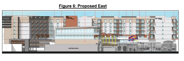
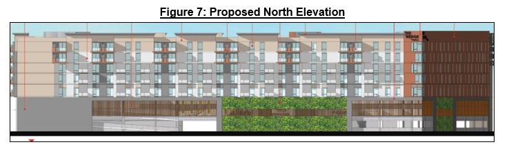
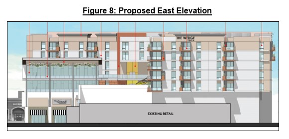
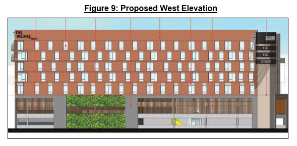
Figures 6 through 9 below show elevations of the proposed building, which is designed with light beige, light and dark gray, and white stucco; wood and metal panels; as well as metal and glass railings. Additionally, the Project proposes building pop-outs, variations in building rooflines, material colors, modulation, and landscaping.
Land Use
Section 20.258.010 of the BCC allows mixed-use development in the MU-I zone, subject to approval of a PD. The Project proposes a mixed-use development consisting of residential and office uses, which are allowed uses in the MU-I zone.
Parking
With the proposed three-story parking garage, the Brea Plaza would provide a total of 997 parking spaces at the site, which is a 258 parking space increase than what is currently on site. Strict application of Section 20.08.040 of the BCC would require1,289 parking spaces for the site, as summarized in the table below.
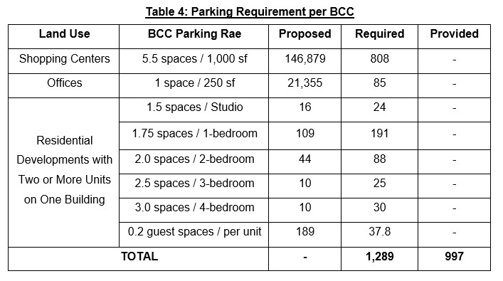
The Applicant submitted a parking demand study, prepared by LSA Associates, Inc. (LSA), that analyzed the site’s peak parking demand with the proposed Project, and assessed whether the site can be accommodated with the proposed 997 parking spaces. The parking demand study was reviewed by City staff, and is included as Appendix K of the Project Draft EIR, provided as Attachment Q.
LSA collected parking demand data at three apartment developments with structured parking, similar to that of the proposed Project. The parking data was collected in 2019, therefore represents typical conditions prior to Covid-19. The three residential sites surveyed were the Core Apartments at 1815 Westside Drive in Anaheim (five-stories tall and 222 dwelling units), the Baker Block development at 125 Baker Street in Costa Mesa (five-stories tall and 240 dwelling units), and Rize at 1100 Synergy in Irvine (five-stories tall and 363 dwelling units). All three of these apartment developments are midrise and provide all of their parking in a parking structure.
Parking accumulation data was collected from these three sites from 5:00 p.m. to midnight for weekdays and weekends. This period was selected to reflect the time of day when Urban Land Institute (ULI) Shared Parking time-of-day data identifies peak resident and guest parking demand. For the Core Apartments, parking ratios were based on the units occupied at the time the surveys were conducted. Property management for Baker Block and Rize reported full occupancy at the time of the parking surveys. Table 5 displays the results of those surveys including the resulting ratios of parking spaces per dwelling unit and parking spaces per bedroom.
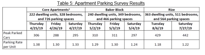
The average parking rates for the three surveyed apartment developments is 1.30 spaces per dwelling (1.38 + 1.30 + 1.33 / 3 = 1.30), while the average BCC parking rate for the Project is 2.09 (per Table 4 above, 395 spaces / 189 units = 2.09). The LSA study concludes that the residential component of the Project can be supported by a 1.30 parking rate, which results in a total parking demand of 246 spaces, or 149 spaces less than the BCC parking requirement. City staff concurs with LSA’s conclusion.
Section 20.08.040(F) of the BCC allows modifications to off-street parking requirements as they relate to shared parking for two or more distinguishable uses where peak parking demand of the different uses occurs at different times of the day, or, where various uses are visited without moving the motor vehicle. Therefore, uses with non-concurrent peak operating times can share all or a portion of the same parking supply. The LSA study includes a shared parking analysis to determine if the proposed 997 parking spaces would be sufficient to support parking peak times for the site. LSA used methodologies found in ULI’s Shared Parking, Third Edition, to identify the daily variations in parking demand for each of the site’s land uses, and avoid double counting parking demand. City staff reviewed the methodology for adherence to industry standards.
During typical weekdays, 966 parking spaces are needed for peak afternoon times and 965 for peak evening times. Meanwhile, during typical weekends, 979 parking spaces are needed for peak afternoon times and 967 for peak evening times. Therefore, the 997 parking spaces proposed would cover typical weekday and weekend peak parking demand.
LSA also evaluated anticipated peak parking demand during December, which is usually the busiest time of year for retail shopping centers. Peak parking demand in December is anticipated to require 1,079 parking spaces in the afternoon and 1,015 parking spaces in the evening. To mitigate parking-related impacts, a parking demand strategy is recommended as a condition of approval (Condition of Approval L in Attachment G) that would include provision of rideshare amenities, subsidizing car sharing for the residents, providing the majority of residential parking in unreserved spaces parking spaces, and the provision of short-term and long-term bicycle parking. Implementation of these parking demand strategies would alleviate parking-related impacts at the site. In addition, the Brea Plaza has a reciprocal access agreement with the Mercury Insurance property to the north that provides an additional 180 parking spaces during business hours, and approximately 500 spaces after 5:00 P.M. on weekdays and all day on weekends.
The LSA study concludes that, when considering the Project’s actual parking demand and the effects of shared parking, the Project would provide sufficient parking to meet typical peak parking demand. Therefore, City staff supports the Applicant’s request for a CUP to allow parking modification as it relates to shared parking.
ENVIRONMENTAL ASSESSMENT
The City as the lead agency consulted with PlaceWorks, Inc. (PlaceWorks) to prepare the Project’s environmental assessment in accordance with the authority and criteria contained in the CEQA Guidelines, and the environmental regulations of the City. As authorized by CEQA Guidelines, based on preliminary review, the City determined that it would prepare an EIR for the Project, and therefore, began working directly on the EIR process and focused on potentially significant effects of the Project. The Project’s Draft EIR (Attachment Q) analyzes potential environmental impacts of the proposed project, including potential pre-construction, construction, and operations impact relating to: Air Quality, Cultural and Paleontological Resources (CPR), Greenhouse Gas Emissions, Noise, Population and Housing, Traffic (Vehicle Miles Traveled/VMT), and Tribal Cultural Resources (TCR). In the Draft EIR, the City concludes that two of these environmental factors (CPR and TCR) would have potentially significant impacts if the Project is implemented. However, as described below, with implementation of mitigation measures, impacts would be less than significant.
Draft EIR Noticing, Comments, and Responses
On July 27, 2020, the City issued a Notice of Preparation (NOP) for the EIR, commencing the 30-day public review and commenting period.
On August 12, 2020, the City held an EIR scoping meeting. A total of 15 agencies/interested parties responded to the NOP, and 13 interested parties provided comments during the scoping meeting.
On August 5, 2021, the City duly circulated a Notice of Availability (NOA) of the Project’s Draft EIR, with a 45-day comment period. During the 45-day Draft EIR review period (from August 5, 2021 to September 20, 2021), a total of 81 comments were received. Pursuant to Section 15088 of Title 14 of the California Code of Regulations, the City prepared responses to comments received on the Draft EIR, that have been incorporated into the Final EIR.
Based on the analysis in the Draft EIR, the Project could have potentially significant impacts to Cultural and Paleontological Resources (CPR) and Tribal Cultural Resources (TCR), that with mitigation measures, were found to be less than significant
Traffic
On September 27, 2013, California Senate Bill 743 (SB 743) was signed into law, becoming effective July 1, 2020, and fundamentally changed transportation impact analysis as part of CEQA compliance. Under SB 743, auto delay (Level of Service) can no longer be used as the criteria for transportation analysis under CEQA.
On October 6, 2020, the City adopted VMT guidelines consistent with SB 743 which states projects generating less than 110 daily vehicle trips may be presumed to have a less than significant impact, and therefore screen out from further VMT studies. LLG prepared a VMT assessment for the Project, that was reviewed by City staff and the City’s Traffic Engineer. The VMT assessment concludes the Project is forecast to generate less than 110 daily vehicle trips and 1,680 fewer daily weekday trips when compared to the existing site conditions. Therefore, the Project screens out from further VMT assessment, and VMT impacts are presumed to be less than significant under CEQA.
Cultural and Paleontological Resources
The Draft EIR studied the potential CPR impacts resulting from the Project. In accordance with SB 18 and AB 52, on July 9, 2020, the City notified local tribes about the proposed project to determine the potential for tribal cultural resources on-site and to determine if local knowledge of CPRs is available about the project site and surrounding area. The City notified the tribes identified by the NAHC pursuant to SB 18 as well as the tribes that, pursuant to AB 52, requested to be notified of all future projects in the City. The following tribes responded:
- Gabrieleno Band of Mission Indians–Kizh Nation.
- Juaneño Band of Mission Indians Acjachemen Nation–Belardes.
- Rincon Band of Luiseño Indians.
- Agua Caliente Band of Cahuilla Indians.
Consultation was only requested by the Gabrieleno Tribe. On July 2, 2021, upon agreeing to mutually acceptable mitigation measures, tribal consultation concluded.
The Draft EIR studied the potential CPR impacts resulting from the Project. Although CPRs were not identified on the Project site, which is fully developed, the Project incorporates the following mitigation measures that would reduce CPR impacts to a less than significant threshold:
Mitigation Measures
The Project incorporates mitigation measures to attempt to limit significant and unavoidable impacts, including:
Mitigation Measure – CUL-1
Would require that a qualified archaeological monitor be contacted in the event that cultural resources are uncovered during ground-disturbing activities. In the event resources are uncovered, the mitigation measure would require additional work such as data recovery, and that the find be reported to the City. Mitigation Measure CUL-1 would reduce potential impacts to archaeological resources to a level that is less than significant.
Mitigation Measure – CUL-2
Would require a qualified paleontologist to be on-call if paleontological resources are discovered during ground-disturbing activities, and allows the paleontologist to temporarily halt activities. Mitigation Measure CUL-2 would reduce potential impacts to paleontological resources to a level that is less than significant.
Implementation of mitigation measures CUL-1 and CUL-2 would reduce potential impacts to archaeological resources to a level that is less than significant.
Tribal Cultural Resources
The Draft EIR studied the potential impacts to TCRs resulting from the Project. Based on records search and the surrounding commercial and residential development, the potential to uncover TCRs at the site is low. However, because the Project would require trenching and other ground-disturbing activities for construction, there is potential to uncover TCRs during ground-disturbing activities. The following mitigation measures have been incorporated to reduce any TCR impacts to a less than significant threshold:
Mitigation Measure – CUL-1
As previously described.
Mitigation Measures – TCR-1
Would require the Project applicant to enter into a Tribal Cultural Resources Treatment and Monitoring Agreement with each Tribe. The Tribal monitor shall be present on-site during the construction phases that involve ground-disturbing activities.
Mitigation Measures – TCR-2
Would require construction activities to cease in the immediate vicinity if TCRs are discovered. All TCRs unearthed by Project activities shall be evaluated by the qualified archaeologist and Tribal monitor.
Implementation of mitigation measures CUL-1, TCR-1, and TCR-2 would reduce potential impacts to Tribal Cultural Resources to a level that is less than significant.
Final EIR and Response to Comments
On October 14, 2021, the Project’s Final EIR was circulated to agencies and interested parties, and was published on the City’s website, https://www.ci.brea.ca.us/166/Projects-in-Process. A total of 81 comments were received and are included in the Final EIR, along with the City’s response to comments. The Project Final EIR is included as Attachment T of this report.
PUBLIC NOTICE AND COMMENTS
This Project was noticed in accordance with the City’s public noticing requirements, which involved mailed notices sent to property owners within 500-feet of the Project site, and publication in the local paper on October 14, 2021. The public hearing notice for this Project is provided as Attachment S. As of the writing of this report, staff has received approximately 80 public comments. Public comments received are included in the Project Final EIR, provided as Attachment U.
Pursuant to CEQA, on July 27, 2020, the City duly circulated a Notice of Preparation of the Project’s Draft EIR, with a 30-day comment period, and held a public scoping meeting on August 12, 2020. On August 5, 2021, the City duly circulated a Notice of Availability (NOA) of the Project’s Draft EIR, with a 45-day comment period.
On October 20, 2021, the City received an EIR comment letter outside of the 45-day comment period that is included as Attachment V of this report. This letter has been evaluated by City staff and consultants and would not change the assumptions and conclusions of the EIR.
The Project has complied with all noticing requirements.
CONCLUSION
For the reasons discussed above and the information attached to this report, the Project would conform with all the goals and policies of the General Plan and the provisions of the BCC. The proposed recommendation would not have an adverse effect on the public, health, safety, or general welfare. Further, pursuant to CEQA, with the implementation of mitigation measures, the Project is would not result in any significant environmental impacts. Therefore, staff recommends the Planning Commission recommend that the City Council approve the Project.
|