Staff recommends that the Planning Commission take the following actions:
- Adopt Mitigated Negative Declaration No. MND 2021-01 (MND 2021-01) and the Mitigation, Monitoring, and Reporting Program (Attachment D) pursuant to CEQA Guidelines Section 15369.5; and,
- Approve Precise Development No. 2021-01 (PD 2021-01) to allow the construction of a new 126,797 square-foot warehouse building, and associated site improvements, based on the findings and conclusions in the attached resolution (Attachment A), and subject to the recommended conditions of approval (Attachment C); and,
- Approve Conditional Use Permit No. 2021-08 (CUP 2021-08) to allow M-2 zoned property located within 300-feet of a residentially zoned property to be developed, based on the findings and conclusions in the attached resolution (Attachment A), and subject to the recommended conditions of approval (Attachment C); and,
- Approve Tentative Parcel Map No. 2021-140 (TPM 2021-140) to allow the consolidation of three parcels into one, public right-of-way vacation of a street segment, and dedication associated with the Project, based on the findings and conclusions in the attached resolution (Attachment B), and subject to the recommended conditions of approval (Attachment C).
|
Location
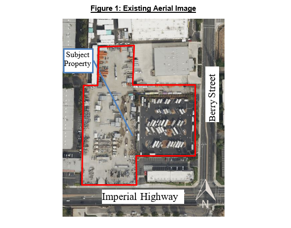
The Project site (reference Figure 1) is approximately 6.4-acres, comprised of three parcels, and located north of Imperial Highway and east of Berry Street. The site has a General Plan Land Use designation of Light and General Industrial and zoning designations of M-2 (P-D) General Industrial with a Precise Development Zone and C-M (P-D) Commercial Industrial with a Precise Development Zone. The project site is currently improved with surface parking areas, temporary modular structures and secured with fencing. Ingress and egress to the site are taken from one drive approach from Imperial Highway and two drive approaches from Berry Street. The zoning designation and existing land use for the adjacent properties are as noted in Table 1.
Table 1: Adjacent Zoning and Land Uses
| Property |
Zoning |
Land Use |
| North |
M-2 (General Industrial) |
Industrial |
| East |
C-M (Commercial Industrial) |
Office |
| South |
R-1 5000 (Single Family Residential) |
Single-Family Residences |
| West |
M-2 (General Industrial) &
C-G (General Commercial) |
Industrial & Commercial |
ENTITLEMENT HISTORY
711 Imperial Highway
In June 2020, the Planning Commission approved CUP No. 20-08 to allow a trailer, storage container and outdoor storage for up to two years by Walter’s Wholesale Electric. This approval is set to expire on or before June 23, 2022. Any extension of this CUP would be subject to review and approval by the Planning Commission. This site is currently operational and occupies two parcels.
285 Berry Street
In November 2020, the City Council approved CUP No. 20-15 to establish a recreational vehicle and boat storage facility. This approval was granted for a three-year time period, with the option for two three-year extensions. This site is currently operational and occupies one parcel.
PROJECT DESCRIPTION
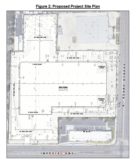
The Project proposes the demolition of existing site improvements that include the removal of temporary modular structures, surface parking lot, fencing and landscaping for the development of the site. The Project, if approved, would construct an approximately 35-foot tall, 126,797 square-foot warehouse building with 9,000 square-feet of office space (ground floor and mezzanine) as referenced in Figure 2. The warehouse building would be setback approximately 155-feet from Imperial Highway and 52-feet from Berry Street. A new surface parking lot for vehicles and trucks would surround the proposed building. The surface parking lot would provide 154 vehicle parking spaces. Vehicle and truck traffic would access the site via two drive approaches on Berry Street. Truck traffic would be limited to exit the site via the drive approaches on Berry Street and vehicle traffic would be able to exit onto Imperial Highway. The proposed warehouse building would have a total of 17 roll-up truck docks, 7 on the north building façade and 10 on the south building façade. New landscaping would be installed along both Imperial Highway and Berry Street frontages. The site would be secured with fencing and driveway gates at each access point. Access to the site would be provided via two drive approaches on Berry Street and the drive approach on Imperial Highway would be modified to a right turn exit only for vehicles. The primary pedestrian entrance would be accessed from Berry Street. The applicant has not identified a use or tenant for the Project. Any tenant seeking to occupy the building would be subject to review by City staff.
DISCUSSION
Precise Development
Pursuant to Brea City Code (BCC) Section 20.260.010, all proposed development within the Precise Development (P-D) Zone shall be subject to review and approval by the Planning Commission. The project site has a zoning designation of C-M (P-D) and M-2 (P-D). In cases where developments occur on a site with multiple zoning designations, the most restrictive zoning development standards are applied. For this project, any circumstances with a conflict in development standards (M-2 versus C-M), the C-M development standards would apply.
The proposed project includes a new 126,797 square foot warehouse building that would be positioned in the center of the project site and would be approximately 35-feet to the top of the roof. Below is a table that demonstrates compliance with all applicable development standards:
Table 2: Development Standards Compliance Table
| Development Standard |
BCC (min./max) |
Proposed |
| Height |
35-feet maximum |
35-feet |
| Setback – Imperial Highway |
50-feet minimum |
155-feet (south) |
| Setback – Berry Street |
20-feet minimum |
52-feet (east) |
| Setback – Interior (north and west property lines) |
0-feet minimum |
57-feet & 252-feet (north)
50-feet (west) |
| Lot Coverage |
50% maximum |
45.5% |
Off-Street Parking Spaces
Office at 1 space per 250 SF for 9,000 SF
Warehousing at 1 space per 1,000 SF for 117,797 SF |
154 minimum spaces |
154 spaces |
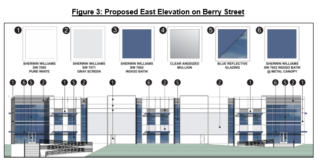
The building would be designed in a contemporary style and would be painted white and gray with blue reflective glazing (reference Figure 3). Façade accents comprised of gray screens and metal canopies are proposed throughout elevation.
As proposed, the building is designed to be complementary to the existing streetscape and to the buildings in the vicinity, and would not adversely impact adjacent properties. Staff is supportive of the PD request for the development of a new warehousing building as proposed.
ENTITLEMENT REQUESTED
Conditional Use Permit
Pursuant to BCC Section 20.240.080 and Section 20.256.050, all proposed development within the C-M and M-2 Zone located within 300-feet of a residentially zoned property shall require approval of a CUP. The project site is approximately 110-feet from the nearest residentially zoned property to the south, across Imperial Highway, therefore the proposed project requires a CUP.
The proposed building would be setback approximately 155-feet from the southern property line adjacent to Imperial Highway and 265-feet from the nearest residential zone. The proposed project is designed to provide the code required on-site parking for a warehouse/storage building. The circulation plan for truck ingress and egress is limited to the two drive-approaches off Berry Street. By routing truck traffic through Berry Street, this would reduce the number of trucks and any potential queuing on Imperial. The drive approach off Imperial Highway would be modified and limited to vehicles exiting the project site via a right turn only. This modification would prohibit any trucks from accessing or existing the site via Imperial Highway. The project site is adequate in size and shape to accommodate the proposed development as the project complies with all applicable development standards.
To further ensure the Project would be compatible with surrounding uses and not adversely affect the public, health or general welfare, staff has prepared draft Conditions of Approval (Attachment C). A notable condition of approval requires that all truck ingress and egress to the site be limited to Saturn Street and prohibited from Imperial Highway (Condition of Approval “d”).
Tentative Parcel Map
The project site is comprised of three parcels (APNs 296-101-03, 296-101-05, and 296-101-08). A consolidation of the three parcels is proposed and would result in code-compliant parcel with respect to lot area, width and depth for the M-2 and C-M Zones. The proposed project would not be allowed if the existing parcels would remain, as the building code would prohibit any structure from being constructed over any property boundary line.
An existing portion of public right-of-way dedicated for the Mariner Street extension, just north of APN 296-101-08, was intended to connect Berry Street and Mariner Street to the west but was never completed. As part of the TPM request, the portion of the public right-of-way would be vacated for the proposed project. Therefore, staff is supportive of the public right-of-way vacation and the lot consolidation proposed within the TPM.
PUBLIC NOTICE AND COMMENTS
This Project was noticed in accordance with the City’s public noticing requirements, which involved mailed notices sent to property owners within 500-feet of the Project site, and publication in the local paper. The public hearing notice for this Project is provided as Attachment H. As of the writing of this report, staff has not received public comments.
Pursuant to CEQA, the Project’s MND was subject to a 21-day public review and comment period. As required, MND No. 2021-01 was made available for public review and comment from September 7, 2021 through September 27, 2021. As of the writing of this report, staff has not received public comments on MND No. 2021-01.
This Project has been assessed in accordance with the CEQA guidelines. As a result, MND No. 2021-1 was prepared for the Project and serves as the environmental clearance document. Mitigation measures identified in the study address impacts to biology, cultural resources, and geology and soils. With these mitigation measures (Attachment C) the Project would not result in any significant environmental impacts.
Assembly Bill – 52 (AB52)
Pursuant to Public Resources Code Section 21080.3.1(b) notices were mailed to California Native American tribes to provide an opportunity to share any knowledge of cultural resources within the Project vicinity or request a tribal consultation. A total of 29 notices were mailed. A request for a tribal consultation was only received from the Gabrieleno Band of Mission Indians - Kizh Nation. The consultation was held and electronic comments and communication was provided by the Gabrieleno Band of Mission Indians - Kizh Nation. Mitigation measures were provided, and include having a Native American Monitor on-site during any ground-disturbing activity. In addition, if any cultural resources are discovered on-site then work shall cease immediately to evaluate the finds.
CONCLUSION
For the reasons discussed above and the information attached to this report, the Project would conform with all the requirements of the General Plan and the provisions of the BCC. The proposed recommendation would not have an adverse effect on the public, health, safety, or general welfare. Therefore, staff recommends approval of the Project. |